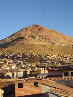
Cerro Rico in Potosí
Bolivia can be divided into three geographic zones:
• the mountains and Altiplano (high plateau) in the west,
• The semitropical Yungas and temperate valleys in the east and north east
• The Oriente, eastern tropical lowlands and grasslands (Chaco)
1. Altiplano- high Andes
The Altiplano extends about 800km from north to south and 130km from east to west. It is enclosed by the Andes mountains, which run in two parallel ranges ( cordilleras ). The western range (Cordillera Occidental) runs along Bolivia's borders with Peru and Chile. Bolivia's highest peak Sajama (6,542 meters) lies in this range. The eastern range (Cordillera Oriental) stretches from Peru to Argentina.
The most prominent feature of the Altiplano is Lake Titicaca, the large lake at its northern end. At 3,810 meters above sea level, Titicaca is the highest navigable body of water in the world. The lake has a surface area of approximately 8,400.00 km 2 . There is a local fishing industry, whose principal species are the karachi and the ispi. Trout, once fished directly from the lake, is now mostly farmed.
2. Yungas and inter-Andean valleys
The northeastern flank of the Cordillera Oriental is known as the Yungas, from the Aymara word meaning 'warm valleys'. As the Andes mountain slopes descend towards the Amazon basin weather systems change: temperatures rise and the rainfall increases. The scenery is very dramatic and the vegetation is lush. This land is among the most fertile in Bolivia, but its agricultural development has been restricted by limited transport links. Bolivia has great biological diversity with at least 20,000 species of plants, many of which can be found in this Yungas region. The inter-Andean valleys, situated around the cities of Cochabamba, Sucre and Tarija, are traditionally the country's main bread-basket.
3. Oriente/ Chaco
The fertile eastern lowlands include all of Bolivia north and east of the Andes, forming part of the Amazon rainforest system, plus the Chaco grasslands to the southeast. Although making up two-thirds of the national territory, the Oriente region is sparsely populated. However, its economic importance has grown rapidly since the 1960s, based mainly on agribusiness and the exploitation of hydrocarbons (oil and gas). Its growing economic importance is centred on the city of Santa Cruz. The lowlands also include the Chapare, in northern Cochabamba, the source of much of the coca used in the manufacture of cocaine. Bolivia's most important gas deposits are in lowland Tarija in the south.
Bolivia lays claim to the seaboard it once enjoyed until this was taken in the War of the Pacific (1879-83) by Chile. This claim remains a potent source of national frustration. Bolivia has tried to negotiate an access to the sea through northern Chile, but such negotiations have never prospered. Formal diplomatic relations with Chile are currently severed.
|